URBAN METOUSIOSIS
Intelligent Cities Studio
Personal Project
Faculty
Willy Muller
Jordi Vivaldi Piera
Starsky Lara
project publication:
IaaC Blog
About:
Jury of selected projects with Wolf Prix, Hernan diaz Alonso and Ron Beit.Session
Term Presentations
METOUSIOSIS is a Greek term (μετουσίωσις) that means a change of οὐσία (essence, inner reality).
Happening in Newark, NJ; this project is an outcome of an extensive research done on Megacities and Programmed Collapse. After studying what a megacity is – a metropolis or more than one metropolis merged together, a megacity is usually defined by a minimum of ten million inhabitants- and what a collapse is – as utilitarian collapse, threshold value collapse, or complete breakdown – of which was studied to infer what a programmed collapse might be and how can a collapse become a design tool.
Mobility was the case study of this project throughout the preliminary research phase; urban mobility in Newark. What can collapse in an urban environment as a cause of urban mobility? How can the mobility system in the city collapse? How is data affecting how we deal with evolving cities? How is technology shifting the paradigm in the world of cars, roads, networked systems? What is the influence of new sharing platforms on traffic in the city? and finally; How would the future look like?
This project is all the research put into work, in a block-scale intervention to the larger urban context.
DENSITY is the major animator of growth and development of cities, density means more demand, more and more, all the time, in a pace sometimes faster than the growth of the infrastructure.
HOW WE READ THE CITY has a lot to how we experience the city, how we design buildings, economic networks, programme distribution… we’ve been displaying cities as 2D, which influenced our circulation in the city, on a “ground level”. Highrise buildings? they look pretty much as a point in a city plan, you go up and down, no lateral displacement. Trajectories in a city are defined by the programme distribution in a city, this tension between places causes a certain flow of people. It is time to think in 3D about cities, to rethink cities as a complete whole, as one object.
URBAN INTERIORS emerge out of density! Museums, Stations, Markets…All these programmes are becoming public interior spaces, and with all the sharing platforms emerging – car sharing, desk sharing, room sharing…- to the smallest property. All this happening at simultaneously, is a major indicator that how we perceive architecture, the urban context and public space is certainly changing. This project tends to study all the circulation inside a block, from the city within to understand how people move, and afterward, change some private to public, tweak some spaces, and change the nature of the existing block.
Urban Mapping
Mapping the urban setting using the following parameters [ occupancy permits across their values, green public spaces, vacant properties, abandoned property, as well as other maps not displayed due to data confidentiality - property value/owners and the traffic daily data of the vehicle type, street name, speed ] these data sets mapped and overlapped, with the emergence of space sharing platforms and community force in Newark, it was possible to render a project of urban mobility and transforming vacant/abandoned spaces in a key location in the city to an urban hub.
Maps realized using Newark open data sets, openstreetmaps and cartodb.

Block-Scale Analysis
As mobility is key in this project, the ground floor of the block and surrounding area was mapped using pedestrian flow data as well as personal data sets made on the different programmes such as cultural institutions, banks, etc. in addition to floor drawings generated after a visit [ measurements and photos ] of the block. The analysis afterward was centralized on three main categories [ vertical: elevator, stairs, etc. public: halls, common areas, etc. and private: internal corridors, etc.

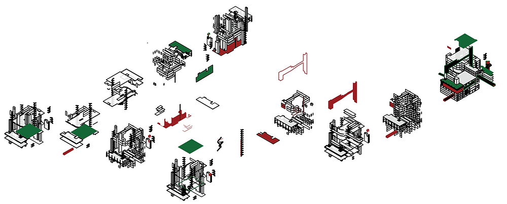
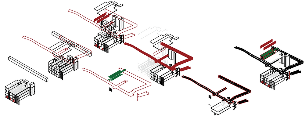
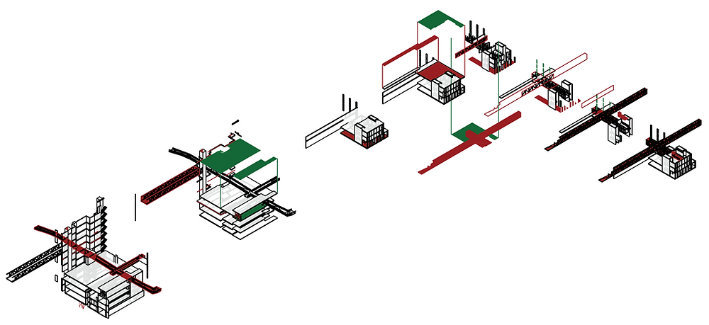
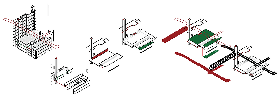
As a quick description of the project; it is a system of interventions, that are the outcome of a translation of how people experience the city, and how the city is evolving to possible changes. Changes happen on the level of architectural elements, such as walls, slabs, stairs, materiality – changing some surfaces to change the utility- and finally adding possible connections from one space to another which are to grow to neighboring blocks and overtake the city in the future – not to mention the emergence of new programmes on different levels which as well is an indicator of the evolution and the interventions made on the block.
This is the story of a block that was a collection of introverted vacant buildings, tweaked to become a super-block, an organism that becomes a center of the city.


Transformation System
More as an operational urban transformation, this is a sample of possible changes [ per building ]. This data-informed system is capable of transforming different patterns in urban data into formal/elemental/spatial interventions; in an attempt to transform the block into a super-block with smaller-scale changes, connections...
Click on the photos for a more detailed view.
Pedestrian flow simulation
pedestrian flow is the key parameter of how transformational operations happen. the different densities of and possible access routes can potentially inform the transformation system across all the other data sets.

Interventions [0]


Circulation elements
Resultant configuration
Block Layering


Delete
Add
Possible Routes [ inside the block ]
Click to pan in a zoomed in view


Urban integration; autocatalyst
Click to pan in a zoomed in view


